Must-see places in Binh Lieu, Quang Ninh
1305 landmark
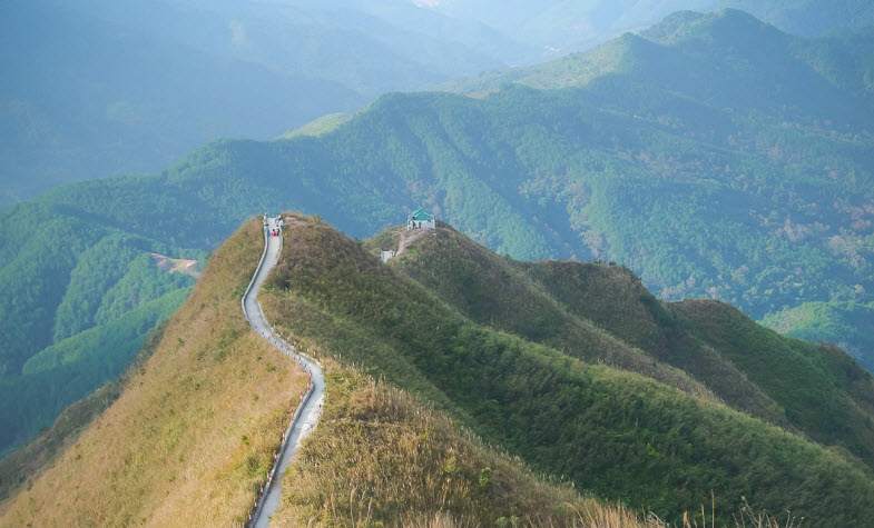
“Dinosaur spine” is the nickname for the mountain ridge found on the way to the Landmark 1305. To reach the landmark travelers must cross this ridge. This is also the most beautiful stretch of road to Landmark 1305, but because the road is quite difficult, it is a pleasant break to stop here to take photos.
Landmark 1305 is located on the Binh Lieu border patrol road. This is one of the two landmarks located at the highest position on the field of Binh Lieu Vietnam, also a place that is not easy to reach. From the Hoanh Mo border gate, you travel to the entrance of the border patrol route, turn right and then proceed along this route for about 18 km. Eventually you will see the parking area with access to Landmark 1305. Follow the trail that has been built out of stairs. It will take about 2 hours to reach the landmark, the total time both going back and forth will be about 3-4 hours, so you should arrange your time accordingly.
Some other milestones
There are 3 large, beautiful and sacred landmarks that cannot be missed when coming to Binh Lieu Vietnam. They are numbered 1300, 1302, 1305 and 1327. From Binh Lieu town, proceed towards Hoanh Mo on National Highway 18C about 3-4 km, then turn right into the village of Ngan Chuong. From Ngan Chuong village, turn left towards landmark 61 (about 7-8km in the direction of Landmarks 1300 and 1302). The time to get to the landmarks is about 1 hour. In addition to these landmarks, you can follow the map and coordinates of the Vietnam-China border landmarks from 1300-1378, as there are quite a few landmarks located on the border patrol route in Binh Lieu Vietnam that you can visit.
Hoanh Mo border gate
Next to Landmark 1317 (2) is the Inter-sectoral Control House of Hoanh Mo border gate, one of the border gates between Vietnam and China. Coming to Hoanh Mo, you can also visit Landmark 1317(2), located on the Vietnamese side.
The mountain peaks in Binh Lieu Vietnam
Suitable for those who love climbing, these peaks have a relatively low altitude and are not too difficult. You can choose to practice here before conquering the more difficult peaks.
Cao Xiem mountain
Cao Xiem is one of the two highest peaks in Binh Lieu Vietnam. To conquer this amazing mountain, you have to make an extended journey of about 15km each way, while experiencing varied emotions when admiring the immense pine forests, the grassy mountainsides, and a misty world of magical clouds.
According to ancient documents, the height of Cao Xiem mountain was thought to be 1,330 meters above sea level. Today, with modern mapping technology, Cao Siam has been confirmed as 1,429 meters high. At this height, Cao Xiem peak is considered to be the "roof" of Quang Ninh.
Goryeo Mountain
Goryeo Mountain is about 1000 meters above sea level. From the Luc Ngu - Khe Tien road going around the mountain on beautiful days, visitors can sometimes catch sight of the sea. But most of the time on the mountain it is foggy and cloudy due to the proximity to the sea and the difference in altitude. Come here to admire the magical moments of harmony between heaven and earth and enjoy the fresh, clean air which carries both mountain and sea breezes.
Keo Lan Mountain
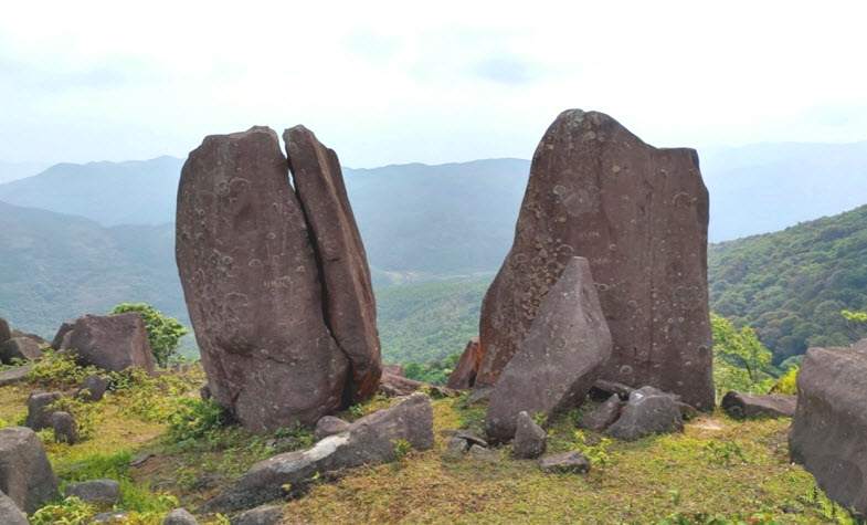
Keo Lan Mountain is located at an altitude of 1,200m above sea level, in the territory of Phat Chi village, Dong Van commune, which is famous for many beautiful tourist attractions. To get to Keo Lan mountain, from Binh Lieu town, visitors move from the direction of Dong Van market up road 1327, to the medicinal herb reserve, turn right, ride a motorbike for more than 1km and then park. From the house to the mountain, it takes about 30 to 40 minutes to walk along the small forest trail. Along the way, visitors will see the purple myrtle flowers blooming, walk under the pine trees and enjoy the fresh air of this mountainous region. Arriving at the end of the pine forest, visitors come upon the opening of a large space with numerous flowers, interspersed with large stone slabs of a variety of shapes.
Cao Ba Lanh Mountain in Binh Lieu Vietnam
With an altitude of 1,050m above sea level, standing on the top of Cao Ba Lanh, visitors can observe a beautiful expanse, covering the whole Vietnam - China border area. Far in the distance a cascade of houses on stilts, terraced fields, and immense green forests can be seen. To reach the top of Cao Ba Lanh mountain, there is only a single rocky road. Furthermore, there are quite a few steep sections with many potentially dangerous turns; on one side is a cliff, on the other side is an abyss. In the past, when there was no road, so people had only one way to reach the top of Cao Ba Lanh: walking. Later, workers brought bulldozers and excavators to widen the road enough for cars to pass, but it was still only a dirt road and in bad weather, the only way to make the trip is still walking.
Quang Nam Chau Mountain
This mountain peak has an altitude of 1507m. While it is actually in the area of Hai Ha district, but the route from Binh Lieu Vietnam is more convenient. You can find your way to Landmark 1327, then ask the locals for the way to ascend to the peak.
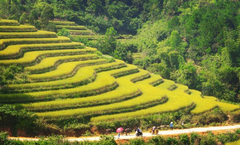
Every October, the scenery of Binh Lieu becomes more poetic with the sweet scent of rice, as the peaceful terraced fields turn various shades of yellow. Here we suggest some places to visit in Binh Lieu Vietnam during the rice harvest season:
• Khe O, Cao Thang, and Ngan Pat villages (Luc Hon commune), are located on the western slope of Cao Xiem mountain, about 3km from National Highway 18C.
• Song Mooc and Khe Tien villages (Dong Van commune) are located on the southern slope of Phieng Che mountain range, about 3km from the center of Dong Van commune.
• Ngan Cam village, Cao Son, and Hoanh Mo commune (the off road to Ngan Cam is right near the snake stream) are all interesting.
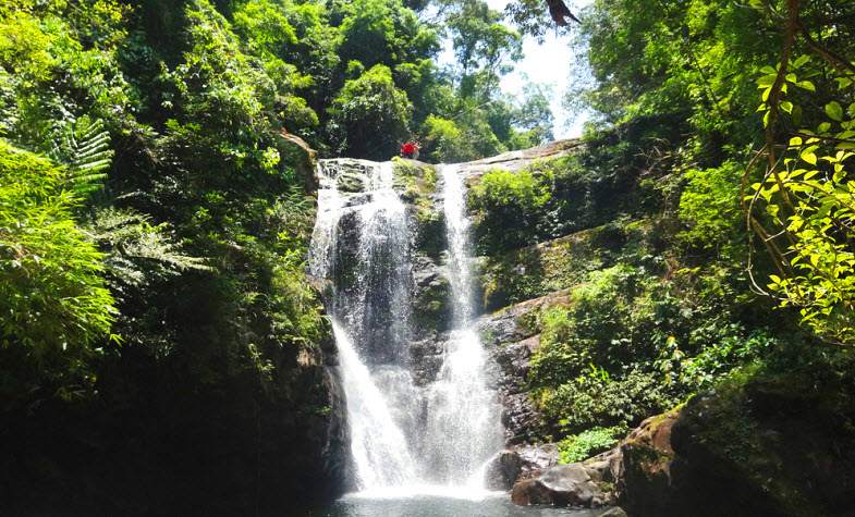
• Huc Dong Commune is the area leading to Khe Van waterfall.
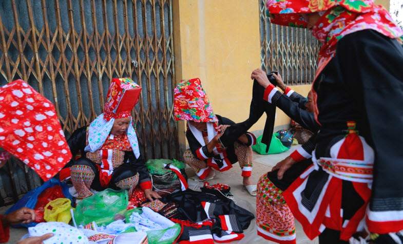
The central market of Binh Lieu town is the market organized by the Tay, Dao, and San Chi people of this district as well as some traders from neighboring districts such as Tien Yen and Dam Ha. Binh Lieu fair market displays an exciting border market culture. Ethnic people come to the market to meet, exchange, eat, and to exchange agricultural products and essential tools. Previously, the traditional fair in Binh Lieu was usually held on odd days (Tuesdays, Thursdays, Saturdays). Today, since the economic conditions of the people in the region are more developed, the consumption needs of the people have increased, and the market has changed to meeting regularly to address socioeconomic needs. The market is busiest every Sunday, when visitors will encounter a vibrant atmosphere of busy sellers and buyers, along with the vibrant colors of the costumes of the Dao ethnic people.
In addition to the central market of Binh Lieu town, Dong Van market also possesses very unique characteristics, although the market is smaller in scale than the central market of Binh Lieu town. Dong Van Market meets in the center of the commune, which is a meeting place for trading of goods and for cultural exchange of ethnic people in Dong Van commune. Goods at the market are also very plentiful and interesting, ranging from household utensils, clothes, shoes, and food, to typical local agricultural products. The market is usually crowded on Saturdays and Sundays. In particular, the fair associated with the "abstain from the wind" event of the Dao Thanh Phan ethnic group (April 4th of the lunar calendar) attracts big crowds. On this day, the Dao people take a break from working. They rest, gather at the fair to meet, eat and drink, sing San Co tunes, and play the instruments of their compatriots. The market is bustling and stimulating, imbued with highland ethnic identity.
Luc Na Communal House belongs to Luc Hon commune. This is the only communal house currently in Binh Lieu district. Luc Na Communal House was built in the late Le period. This interesting structure is a place to worship the god of peace.
Khe Van waterfall originates from the Khe Van mountain range - Thong Chau with an altitude of more than 1000m above sea level. The waterfall has 3 layers of flowing water with a height of about 100m, pouring down in white cascades among the grass and rocks. This is a spectacular waterfall flowing over large boulders. The two sides of the waterfall are moss-covered cliffs. In the rainy season, the waterfalls release white foam to form small clear lakes at the base. Khe Van waterfall, with its pristinely protected forest and rich vegetation, is a place to enjoy the natural environment, creating a sense of relaxation for each visitor to swim in the clear water and breathe the fresh air.
Khe Tien waterfall in Binh Lieu Vietnam actually consists of three waterfalls, Khe Tien 1, 2, and 3. The waterfall complex is formed from the geysers at the foot of the mountain, forming small streams of water pouring downward. Khe Tien waterfall is located in the middle of the primeval forest in Khe Tien village, originating from the Quang Nam Chau mountain system 1500m above sea level. The waterfall has an altitude of 749m above sea level with high humidity, and flows year-round in dense fog. The waterfall still retains its wild and poetic look.
Khe Tien waterfall complex has a unique beauty with a variety of forms. Waterfall 1,2 flows together to form a large lake, and waterfall 3 radiates many cascades. According to folklore, there is a 7-colored stone at Khe Tien waterfall which supposedly offers good luck and prosperity, so visitors always search for it.
Song Mooc waterfall is a small chute, a cascade 10m high flowing down to form the waterfall. At the base is a system of magnificent rocks and boulders creating an area of stone beach which is more than 4000m2.
Mooc River is a highland village located in Dong Van commune, with a total natural area of over 375 hectares. Agricultural land accounts for only 69 hectares (18.4% of the natural area), because the whole village is located on the slopes of the Phieng Che - Cao Ba Lanh mountain system (over 1000m high). The agricultural land is mainly terraced fields. The location of Song Moc village provides distinct elevation differences, with the lowest point only about 300m above sea level and the highest over 700m, creating beautiful terraced fields with houses still retaining traditional indigenous architecture. In addition, there are cinnamon and fragrant anise forests in the village which are also unique characteristics of this area.
In terms of population, the Mooc River area is the home of the Dao ethnic group (100% of the population is the Dao ethnic group) with 719 people in 154 households.The community here still retains many traditional cultural features imbued with national identity.
***
Travel Authentic Asia Company is your best choice for discovering the beauty of Southeast Asia. Our experienced and knowledgeable travel advisors are committed to helping you create a tailor-made tour and extraordinary experiences in this majestic region.
If you're looking for an authentic cultural experience, do not hesitate to contact Travel Authentic Asia to choose a Vietnam tour or to customize your own style tour to Southeast Asia.

.jpg)
.jpg)